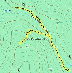
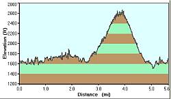
Hiking with Sonja in Oregon and Washington, August, 2008
In August of this year, I was lucky enough to have one of my best friends come visit us in our new house in Portland. Sonja came to stay for just over a week and we sure had fun hiking and biking. The weather was too hot for motorcycling (104 anyone?!) but we managed to be cool in the forests and caves of Mt. Hood National Forest and Mt. St. Helens National Volcanic Monument Area.

We also had fun visiting with Ron & Greg and Sonja's friend Flavia and her daughter. And we managed to get some shopping in, eat terrible Thai food, delicious Cuban food, and do tons of research on GPS units, heartrate monitors, and bicycles. I hope she comes again soon, we certainly miss her smile around the house!
 

GPS track

Elevation Profile
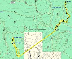
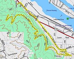
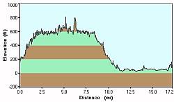
Our first outing was a hike from the base of Multnomah Falls, all the way up to the top of Larch Mountain. It was a lovely day, sunny and not too warm (mid-80's). The one-mile path to the top of the Falls took us to 660 feet elevation. After admiring the view, we hiked 
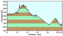
the other 3500+ feet over 8.8 miles to the tippy-top of Larch Mountain, where we could see five other mountains all around us. The platform they have constructed gave us a 360-degree view of the cities of Portland & Vancouver, as well as Mt. Rainier, Mt. St. Helens, Mt. Adams, Mt. Hood, and Mt. Jefferson. On this day, Mt. Rainier and Mt. St. Helens were pretty covered in clouds, but that didn't dampen our happiness a bit. As it happens, there is a paved road that goes to the top of Larch Mountain so...you know...there are options.

We hiked through some beautiful forests, across log bridges, past all sorts of fungi, and even an area of woods that had recently burned. It was a long day, but we had plenty to eat, drink, and talk about so the miles melted beneath our shoes. I tripped and fell once, landing hard on my arms, but sustained no injuries other than to my pride. The descent was tricky as the light was fading and the shadows grew long. I also dropped my camera over a ledge, but it caught on a bush and so did not fall the 20 feet to its demise in a creek. Sonja held on to my leg as I reached and reached and just barely got hold of the camera's strap. I've been wanting a new one, but this just wasn't going to be the day for me to lose all my photos!

(click on either of the images to see a page of photos from each outing)


GPS track

Elevation Profile
Our second outing was supposed to be a series of trails in the Trapper Creek Wilderness area. But we didn't have a good map, so we decided to hike the trail to the top of Silver Star Mountain, in the Gifford-Pinchot National Forest near Mt. St. Helen's.

After stopping at a ranger station for a detailed map, we headed out a dirt road that got worse and worse. Unfortunately, we did not have the pickup truck that day, so we had to decide not to drive down the washed-out, rutted road to the trailhead. Instead, we stopped at the Starway Trailhead. Starway also goes to the top of Silver Star Mountain, just from a different angle. Luckily, we had our guidebook with us so we were easily able to change plans. The Starway Trail is a killer, though, as we found out when we finally located the cairn for it. It goes UP. UP and UP and UP. It was like walking on a stalled escalator. So steep that when we stopped for a snack, we had to hold on to our packs or they would tumble downhill. We climbed and rested and climbed, but eventually decided that we just weren't having fun and called it a day. Picking our way back down the trail was treacherous, and we both quickly found hiking sticks to lean on.

The trail was lined with pretty wildflowers and was obviously rarely used. There was fresh bear scat (like, really fresh) so we kept an eye out as we walked. When we got back to the creek, we paused to read the warnings about mining in the area. I'm not sure what they mine for, but folks are pretty vocal about this or that area already being "staked". Since nearby creeks and mountains are called "Copper" this and "Copper" that, I suppose there's copper in them thar hills. We explored the area by car for a while longer, getting chased out of a parking lot by the campground host on an ATV (we didn't have our Forest Pass yet and hadn't paid the $5 fee to park there), then we returned to Portland for an evening 'in'.

(click on either of the images to see a page of photos from each outing)


GPS track

Elevation Profile
Our third outing was to June Lake and Ape Cave in the Mt. St. Helen's National Volcanic Monument area. As with the previous day, our plans changed on-the-spot when we discovered that the road to Ape Canyon was washed out. We tinkered with the idea of hiking some of the Loowit Trail that goes all the way around the rim of the volcano, but by the time we got to June Lake, the heat was getting the better of us. It was 102 in Portland that day. I'm not sure how hot it was for us up there on the volcano, but it was plenty hot for me!

June Lake was very pretty. It's fed by waterfalls on one end and depleted by Swift Creek (the creek that took out the road) at the other. In between, it is serene and peaceful. But it's also full of life: we saw frogs in it, and birds & bugs galore. We had lunch there and then hiked back to the car to explore Ape Cave.

Ape Cave is a lava tube that's just over a mile long. It's the longest lava tube in North America, and the second longest in the world (the longest is in Africa). You can hike through it at one opening and come out the other end if you have two flashlights and aren't afraid of the dark! It felt strange putting on our long sleeved shirts in the parking lot, but when we got to the mouth of the cave and started descending, we sure were glad to have them. The cave was cold, dark, and spooky, but there were enough other people in it that it wasn't creepy. Once in the cave, the going can be tough. There are piles of sharp rocks that you have to climb, and at one point, an eight-foot wall of solid rock to scale. We had a wonderful time, although we did take a wrong turn and end up crawling on our stomachs for a bit (oops!!). This was my third time in Ape Cave and I'd happily go again. It's just so neat, all the rock formations and layers of rock in the walls. It was formed by super-hot lava pushing its way through the mountain, literally. It was a very violent time, you can tell by the long scratches carved in the walls as you go through it. The force with which the lava must have been pushing is just unimaginable. A great hike for a hot day!

After the cave, we drove to Lewis River and checked out Lower Falls. Beautiful!

(click on either of the images to see a page of photos from each outing)


GPS track

Elevation Profile
For our fourth day out, we rented bicycles and toured Forest Park (well, about five miles of it, anyway). We had been looking at different bikes for me all week and reading about them, talking to people, and scanning websites, so it was time to make a decision. We rented four bikes: first we took out a Giant XLC hardtail with front suspension and another type of Giant that had front and rear-suspension. We rode those into the park, smiling at everyone we passed along the way. The road we were on was called Leif Erickson and is not paved so we got the full idea what it's like to ride those bikes. I thought the park seemed crowded, but it really wasn't too bad. It was Saturday, after all!

After the park, we turned in the bikes and got two more. I took a fast street bike and Sonja opted for the Townie, a cruiser-style three-speed that she soon began to hate. I think her exact words were "That bike needs to be burned". Not fun. All the research and test-rides paid off, though, because the next week when I bought my Cannondale, I felt confident in the purchase. It's a fun bike and I predict many miles of happiness on it. I haven't gone on single-track stuff yet, but I will!

(click on either of the images to see a page of photos from each outing)


page maintained by
Cheryl