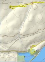
The trail - 2.2 miles

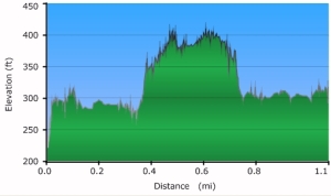
Elevation Profile
| Horsethief Lake & Bluff and Columbia Hills State Park, April, 2011 |
Click on the small pictures to see larger ones. |
| Learning about "She Who Watches" at Horsethief Lake State Park, climbing Horsethief Butte, and exploring an abandoned homestead in Columbia Hills State Park. Oh, and a quick trip to the fish laddeer at the Bonneville Dam to watch the salmon! |
|
Today's outing was not so much a 'hike' as an educational stroll with some exploring and rock-scrambling thrown in for good measure. My curiosity
about the many petroglyphys and pictographs on display at Horsethief Lake State Park in Washington finally got the better of me,
so I got up early and set out. According to the literature, natives originally carved some of them on the canyon walls near Selilo Falls. But when the Columbia
River was dammed in 1957, tribal elders worked with the US Army Corps of Engineers to move them to a location that would be above the new
water line. The canyon was flooded and Selilo Falls consumed by the lake that formed.
Although these pieces have lost much of their significance because they are no longer in situ (kind of like viewing a Christian cross in
a museum), there are some pictographs and petroglyphs still in their original locations high above the water. These works retain their original messages
and are considered sacred by the First People.
While the relocated pieces can be viewed via a self-guided tour, the in situ pieces can only be visited by non-natives as part of a guided walk offered just twice a week, on Fridays and Saturdays at 10am. I signed up for this walk last February and set my alarm to get up early to make the drive from Portland. It was a free tour and it was hands-down the best ranger-led walk I've been on in years. |

The trail - 2.2 miles |

Elevation Profile |
|
First, I toured the pictographs and petroglyphs that were moved from the canyon. They were amazing! Very striking in their variety and their sense of life and action. The self-guided 'tour' did not offer much information about the figures, such as stories or names, but I think that's because these are religious figures for the First People and they prefer a sense of privacy. I watched the mighty Columbia roll by for a while and then the ranger arrived for our 10am tour of the in situ pieces. |
|
The tour was great as there were only three other people on it, so we had a small group of five. We headed out along the hillside down river and were immediately immersed in the past. Our ranger spent a long time talking about native art, and he taught us about the different styles of eyes that the figures have and what they mean (different tribes) and the possible meaning of some of the adornments. He took his time, answered questions, and we all felt free to speak and suggest meanings, and point out what we saw. Some of the figures are quite faint and you have to wait a while for them to emerge from the rock and be visible. It can be startling to be standing there looking up at something and then realize that there are a pair of eyes right by your shoulder! |
|
But the star of our show was She Who Watches,
a combination pictograph/petroglyph that probably is about 500 years old. She's quite big, maybe 4-1/2 feet across, and very intense. Her name is
"Tsagaglalal" and there are different stories about her. The ranger said that her image is used in other places around the area, all of which turned out
to be cremation grounds for the natives. When a person died of a communicable disease, their remains were burned instead of buried, and it's thought
that perhaps this image was used to convey the danger of infection. But other stories are less disturbing, and the ranger spent a long time telling us one
that he'd heard a native tell his daughter one day while they were visiting the site. In short, the face is of a young girl who saw a war band approaching
her village and warned them of the danger. She managed to distract the army long enough for her village to collect its food stores and get away, but
she was buried in a rock slide. When they cleared the rocks to find her body, all they found was this image.
|
|
Back at the Horsethief ranger station, I lucked into meeting 'that' ranger. You know, the one who is in a great mood and who knows the really cool places and, for whatever reason, is eager to share the area's secrets. He told me about Dalles Mountain Ranch, a bunch of acreage that had just been annexed to Columbia Hills State Park. The acquisition was so new that the current maps didn't show it as being park land, but it was. He showed me on the topo map where an old homestead is, and said to pay particular attention to the well. He said not many people know about it and there's not really a trail, but if I looked, I could find a rutted two-track road and could follow it most of the way. He promised me wildflowers and a sense of discovery, and boy, was he right! |
|
I drove up a nameless dirt road to a gate and parked. Well, to tell the truth, I drove right past the gate all the way to the other side of the park before realizing my mistake, but then on the way back, I found the old road and parked the car. The park spans the massive, rolling hillsides along the north side of the Columbia and I had terrific views all around me as I struck out to find the old homestead. It was very windy as I walked, but the sunshine kept me warm. The grass gracefully billowed and swayed in the wind and the flowers were more lovely than I could have imagined. It was like walking in a wildflower calendar! The lupines (the blue flowers in these photos) are especially nice because they're so soft. I spent a few minutes petting one and it felt like lamb's wool. |
|
I found the homestead after about a mile of easy walking. There were remains of a small stone cabin and a root cellar, but best of all was the well.
As far as wells go, it was average, and in fact it had been sealed up and piping installed to fill a nearby trough. What made the well neat was
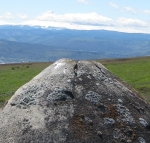
the concrete top to it. The homesteader, Bill Brune, had poured concrete and molded it in an exact replica of Mt. Hood, which towered just across the
river. If you stand just right and line up the wellhead with the mountain, it's really very good! I tried to line the view up with my camera, but there were
clouds forming at the base of the mountain which made it hard to photograph.
|

|
|
Eventually, though, I walked back to the car and checked the clock. Hm, only 2:30pm, plenty of time to see more of the area. So I went back to my friendly ranger and learned about Horsethief Butte, just across the lake. He gave me a map of the 500-foot tall rock and I headed over there to explore. The top of the butte is easy to reach and is honey-combed, with many nooks & crannies to explore. There are more pictographs there, too. The view from the butte was terrific and I spent a long time looking around and climbing boulders. Eventually, though, I turned my wheels back toward home. I stopped at the Bonneville Dam to see if the salmon were climbing the fish ladder, but only saw a few fish, not nearly the jostling crowds that I've seen in the past. Oh, well, it's only the first of May, they are coming upriver as fast as they can swim, and I'll be here to greet them! What a fantastic day it was. Not hard or particularly strenuous, but filled with information about the people who have lived here before me. |
